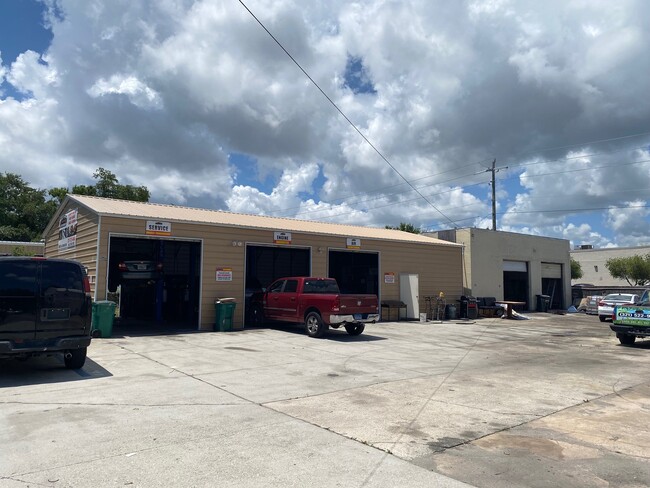
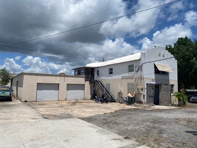
Property Record
71 Sunset Dr, Melbourne, FL 32904

NEARBY LISTINGS FOR SALE OR LEASE
Property Detail
71 Sunset Dr
Palm Bay-Melbourne-Titusville, FL
Westover
28-37-05-77-00005.0-0018.00
WESTOVER LOTS 18 THRU 24 & LOT 25 LESS THE S 9.96 FT BLK 5
Commercialnec
Brevard
X
Florida
12009C0584G
18
2024
0.58 AC
2025
Brevard County
065022
Orlando
11,650 SF
DEMOGRAPHICS near 71 Sunset Dr
1 Mile
3 Mile
5 Mile
2024 Total Population
9,283
63,257
148,217
2029 Population
10,171
69,580
162,437
Pop Growth 2024-2029
+ 9.57%
+ 10.00%
+ 9.59%
Average Age
45
44
44
2024 Total Households
3,911
27,084
62,787
HH Growth 2024-2029
+ 9.51%
+ 9.93%
+ 9.46%
Median Household Inc
$53,695
$55,475
$59,186
Avg Household Size
2.20
2.20
2.20
2024 Avg HH Vehicles
2.00
2.00
2.00
Median Home Value
$248,180
$240,014
$240,828
Median Year Built
1984
1987
1985
Nearby Places
Map Layers
Map Styles
 Street
 Aerial
- Restaurants
- Banks
- Shops
- Fitness
- Groceries
PUBLIC TRANSPORTATION
AIRPORT
Melbourne Orlando International
DRIVE
WALK
Distance
Melbourne Orlando International
9 min
2.3 mi
SALE & LEASE HISTORY
LISTING DATE
SALE/LEASE

May 26, 2024
For Sale
Nearby Properties
Address
Land Use
TOTAL SIZE
Lot Size
Zoning
Address
Land Use
TOTAL SIZE
Lot Size
Zoning
1,105,462 SF
18.74 AC
CC1
Address
Land Use
TOTAL SIZE
Lot Size
Zoning
1,245,196 SF
110.73 AC
I1
Address
Land Use
TOTAL SIZE
Lot Size
Zoning
506,643 SF
80 AC
RA
Address
Land Use
TOTAL SIZE
Lot Size
Zoning
380,944 SF
32.18 AC
RA
Address
Land Use
TOTAL SIZE
Lot Size
Zoning
458,852 SF
23.05 AC
GU
Address
Land Use
TOTAL SIZE
Lot Size
Zoning
391,740 SF
30 AC
Address
Land Use
TOTAL SIZE
Lot Size
Zoning
582,248 SF
65.30 AC
RA
Address
Land Use
TOTAL SIZE
Lot Size
Zoning
475,791 SF
229.02 AC
M1
Address
Land Use
TOTAL SIZE
Lot Size
Zoning
265,272 SF
21.17 AC
M1
Address
Land Use
TOTAL SIZE
Lot Size
Zoning
265,062 SF
14.75 AC
M1
Address
Land Use
TOTAL SIZE
Lot Size
Zoning
373,700 SF
12.96 AC
Address
Land Use
TOTAL SIZE
Lot Size
Zoning
332,802 SF
37.02 AC
I1
Address
Land Use
TOTAL SIZE
Lot Size
Zoning
368,326 SF
14.77 AC
C1
Address
Land Use
TOTAL SIZE
Lot Size
Zoning
672 SF
57.80 AC
I1
Address
Land Use
TOTAL SIZE
Lot Size
Zoning
387,843 SF
27.19 AC
R3
Address
Land Use
TOTAL SIZE
Lot Size
Zoning
197,734 SF
27.99 AC
M1
Address
Land Use
TOTAL SIZE
Lot Size
Zoning
349,772 SF
16.27 AC
R2
Address
Land Use
TOTAL SIZE
Lot Size
Zoning
297,886 SF
32.38 AC
C-1
Address
Land Use
TOTAL SIZE
Lot Size
Zoning
213,482 SF
1.27 AC
Address
Land Use
TOTAL SIZE
Lot Size
Zoning
261,552 SF
23.21 AC
R2
Address
Land Use
TOTAL SIZE
Lot Size
Zoning
268,487 SF
20.08 AC
RA
Address
Land Use
TOTAL SIZE
Lot Size
Zoning
280,518 SF
13.88 AC
Address
Land Use
TOTAL SIZE
Lot Size
Zoning
24.95 AC
I1
Address
Land Use
TOTAL SIZE
Lot Size
Zoning
295,347 SF
14.61 AC
R2
Address
Land Use
TOTAL SIZE
Lot Size
Zoning
213,704 SF
0.57 AC
CC3
Address
Land Use
TOTAL SIZE
Lot Size
Zoning
542,262 SF
51.88 AC
CP
Address
Land Use
TOTAL SIZE
Lot Size
Zoning
330,705 SF
25 AC
I1
Address
Land Use
TOTAL SIZE
Lot Size
Zoning
270,428 SF
19.69 AC
R2
Address
Land Use
TOTAL SIZE
Lot Size
Zoning
309,725 SF
14.70 AC
R2 (6)
Address
Land Use
TOTAL SIZE
Lot Size
Zoning
184,447 SF
14.06 AC
R2
The World's #1 Commercial Real Estate Marketplace
Connect with us
© 2025 CoStar Group
The information above has been obtained from sources believed reliable. While we do not doubt its accuracy we have not verified it and make no guarantee, warranty or representation about it. It is your responsibility to independently confirm its accuracy and completeness. Any projections, opinions, assumptions, or estimates used are for example only and do not represent the current or future performance of the property. The value of this transaction to you depends on tax and other factors which should be evaluated by your tax, financial, and legal advisors. You and your advisors should conduct a careful, independent investigation of the property to determine to your satisfaction the suitability of the property for your needs.